|
Revolutionary War Trails:
Ninety Six
Article by Tom Straka
Photographs by Pat Straka
 |
 |
|
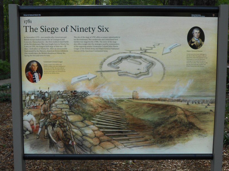
Two interpretative signs give a feel for
the size and shape of the fort. Note the sharpened stakes,
sandbags, and ditch.
|
Which state can claim the most Revolutionary War
battle sites? Probably Massachusetts or Virginia came to your mind.
South Carolina can claim that distinction with 250 Revolutionary War
battle sites. One of the major battle sites is Ninety Six. In the 1700's
it was at the edge of the frontier, strategically located at the
intersection of major Indian trails and, supposedly, 96 miles from the
Cherokee Indian village of Keowee. The location made it a trading hub.
In 1760 frontier friction between Indians and settlers developed
and a stockade was quickly built at Ninety Six. Fort Ninety Six offered
protection from two Indian attacks.
A peace treaty allowed settlement up to the Keowee area.
 |
|
The approach to
the star fort, remnants of
trenches and parallels in the
foreground.
|
By the time of the Revolutionary War it was a commercial center that
included a courthouse at the critical crossroads on the road from
Charleston to the frontier. It
was also the most westward British outpost in the colonies. The first
Revolutionary War battle south of New England occurred in Ninety Six in
1775. About 600 patriots
had built a stockade at Ninety Six and held off about three times as
many loyalists. Both sides agreed to a truce and the fort was razed.
Later the patriots attempted to sweep the loyalists from the area.
Patriot and loyalist factions left the area primed for a major battle of
the war.
The second British campaign to conquer the South
from 1778 to 1781 resulted in the capture of Savannah and Charleston.
Charleston was the commercial capital of the South and its fourth
largest city. By 1780
loyalists held most of Georgia and South Carolina. General Lord
Cornwallis moved his army northward but suffered major losses at Kings
Mountain in late 1780 and at Cowpens in early 1781. Patriot General
Nathanael Greene soon faced Cornwallis at Guilford Courthouse, N.C. and
suffered heavy casualties while winning that battle. Cornwallis was
forced to move towards the safety of the coast and Greene did not
follow. Instead Greene decided to attack the British chain of
backcountry outposts.
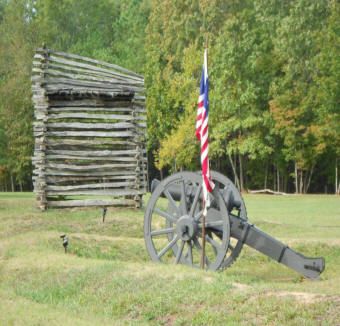 |
|
The ten-foot rifle tower (original was
thirty-feet).
|
Ninety Six was a major loyalist outpost garrisoned by 550 men. The
village was stockaded and a star-shaped fort had been built.
The eight-sided star allowed marksmen perfect lines of sight for
any attack. The fort was
surrounded by a ditch and its side was covered by sharpened stakes;
sandbags on top extended its height to 14 feet. The village and fort
were connected by a covered trench walkway. At night this trench was
used to obtain water. The remains of a 25-foot well inside the fort
remain today from an unsuccessful attempt to secure water from directly
inside the fort.
When Greene and his 1,000- man army arrived in
May of 1781, the impregnable
fort discouraged any type of direct attack.
Instead a siege was the tool to take down the star fort.
Colonel Thaddeus Kosciuszko, a renowned
Revolutionary War military engineer, was assigned the task of directing
the siege. Sappers (trench diggers) began to dig a series of approach
trenches and parallels. Each parallel would be closer and closer to the
fort. Within two weeks the third parallel was complete and the patriots
were within musket range of the fort. During the cover of darkness a
30-foot log tower was built that allowed marksmen to shoot down into the
fort. Then Greene got word that 2,000 British troops were marching
towards the fort as reinforcements. It was time to storm the fort or
become trapped between the two British forces.
 |
|
The stockade that surrounding the
village.
|
Colonel Henry "Light-horse Harry Lee" captured the stockade fort and
6-pounder cannon fired on the star fort. But the thick earth fort walls
were too much for the cannons. Greene sent 50 men to clear a path for
the main force. Axes were
used to cut the sharpen stakes and sandbags were pulled off the top of
the fort with hooks. Loyalist troops entered the ditch and hand-to-hand
combat drove the patriots back with great losses. This had to decide the
battle as the British relief column was approaching. Greene was forced
to move his forces northward. However, the outpost was weakened and
within a month the loyalists abandoned Ninety Six and moved closer to
the coast.
What is there today? The star fort still exists,
weathered through time, certainly no longer 14-feet tall, but very
easily discernable. The
approach trenches and parallels are also clearly visible.
There is even the only tunnel used in warfare
during the Revolutionary War. Kosciuszko had a 6-foot deep vertical
shaft dug and then sappers started a trench towards the fort's wall.
Once at the fort, power charges would be used to blast open the
wall. The tunnel was not completed before the siege ended. A10-foot
reconstruction of the log rifle tower is on the battlefield. The
communications trench between the village and fort is intact. Stockades,
cabins, cannon, village sites, and parts of colonial roads and Indian
trails are all parts of the historical site.
  |
|
|
Frontier log cabin is part of the site |
Reenactors are often on the site with
living history demonstrations. Robbie "Capt." Gilbert amd David
Blackwelder (in the tricorne).
|
|
There is a modern visitor center, with a museum, bookstore, restrooms,
and short video film. All
of the sights are on a one-mile walking tour. The path is paved and the
route is circular. There is an observation platform that allows a
wonderful overview of the fort and battlegrounds. Interpretative signs,
with photographs, maps, and text are strategically located on the trail.
While the theme is the battle site, there are log cabins and displays
that highlight colonial frontier life.
When I began the walking tour, starting out in a small woodland
area, I could hear a colonial fife, barely audible, playing in the
distance. I assume it was part of the walking tour, probably
triggered electronically. But you never know. The place certainly
could harbor Revolutionary War ghosts. It is one of those places you
can feel the spirit of, with history clearly in view.
Ninety Six is located between Greenville, S.C.
and Augusta, Ga. It is a couple of hours from Cowpens and Kings Mountain
historical sites. The
combination would make a great Revolutionary War tour.
Periodically the site has historical reenactments and special
events.
Author:
Thomas J. Straka is a forestry professor at Clemson University in South
Carolina.
For more
info:
National Park Service, Ninety Six National Historic
Site (Official Website)
http://www.nps.gov/nisi/index.htm
South Carolina Department of Archives
and History (Photographs)
http://www.nationalregister.sc.gov/greenwood/S10817724001/index.htm
South Carolina Department of Natural Resources
Video (Park Tour)
http://www.facebook.com/video/video.php?v=1094911183507
Explore Southern History Website
(History and Photographs of Ninety Six)
http://www.exploresouthernhistory.com/ninetysix.html
National Park Service, Southeast
Archeological Center (Archeology and History of Ninety Six)
http://www.nps.gov/history/seac/96arch.htm
National Park Service, Southeast
Archeological Center (Archeology and History of Ninety Six)
http://www.nps.gov/seac/96arch-bg.htm
History Comes Alive at Ninety Six
National Historic Site
http://www.discoversouthcarolina.com/files/smiles-pdfs/NinetySix.pdf
Author:
Thomas J. Straka is a forestry professor at Clemson University in South
Carolina.
|